Are urbanized centres becoming ideological fortresses, isolated from rural areas and even suburban and regional centres?

Artistic representation of ProRep support in BC
Building on my ‘hot take’ on the BC ProRep referendum results, maps of the referendum results indicate similarities with Brexit and the 2016 US presidential election, demonstrating the separation (or isolation) between urban (city) and other regions.
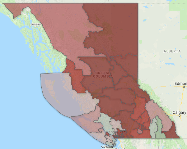
In the recent ProRep referendum, ProRep succeeded in only 16 of 87 ridings. Support was mainly concentrated in urbanized areas. Six were on the South Island, six were in the City of Vancouver, plus New Westminster. The remaining three were Powell River-Sunshine Coast, and two in the West Kootenay – not surprising given their political traditions. Here’s how the results look according to two mappers who put their work on Twitter:
BC ProRep map (published on Twitter by Andy Yan (@AYan604), Director of SFU’s City Program:

The green (and purple) indicates where ProRep passed.
The red and orange areas show where ProRep did very poorly – in suburban (and diverse) communities in Metro Vancouver, the Fraser Valley, and most ridings in the Interior.
Another map of the BC referendum results was published by Rhea Donsman (@repdonsman456), who describes herself as a political analyst and strategist.
The province-wide map shows the bloc of FPTP support in the Interior, while the Lower Mainland / South Island map below shows the pockets of ProRep support in relation to the Metro Vancouver suburbs and Fraser Valley.
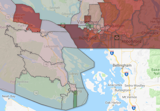
In both of the referendum maps (Yan’s and Donsman’s), you can see the geopolitical differences.
Brexit results by region (source: Vancouver Sun):
Let’s compare the BC referendum results to Brexit.
This map makes the point – London is an island in England, with the countryside and regional cities seeing things differently. By comparison, Scotland plays the role of Vancouver Island (and Northern Ireland – the West Kootenay?) in terms of seeing things differently than England outside London.

US 2016 presidential election results by county (source: Wikipedia):
The 2016 US presidential results map (by county) shows the concentration of Democratic Party support on the populated coasts and the domination of the Republicans in the less-populated ‘flyover states’.
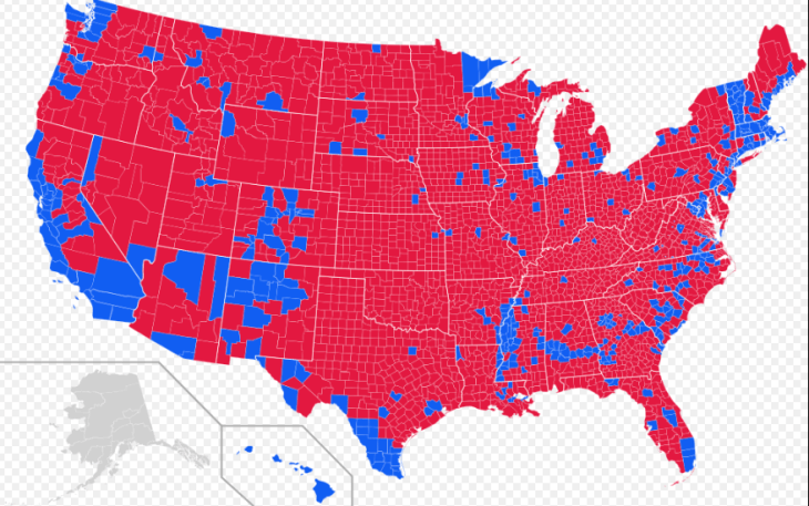
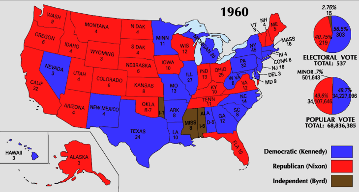
It wasn’t always this way in the US. In 1960, JFK won in the South and Nixon won the west coast.
Maps are ever-shifting, but in today’s examples, the urban consensus does not have a lot of support in the outlying, rural areas.
Traditional notions of “right” and “left” are being displaced by place. It’s always been this way, to an extent. But is it more pronounced today? In the US, it seems so. With Brexit, it exposed faultlines on Euroskepticism that have existed since the UK entered the EU. In BC, parties have tended to draw from all regions throughout history but in recent elections there has been a trend toward regional domination (with the Metro Vancouver suburbs lying in the balance).
Going deeper in BC – Vancouver Island is very different from the rest of BC. It’s much less ethnically diverse and it’s a lot older. However, on the Island, we see the difference between the South Island and equivalently sized region ‘North of the Malahat’. The South exhibits urban, green values, while the North is more influenced by rural and resource issues. Environmental values in that area vary between those who generally side with producers versus those who prefer an alternative economy, such as those who live on gulf islands between Vancouver Island and the Mainland.
In the Lower Mainland, higher income areas with lots of post-graduate degrees, in parts of Vancouver, the North Shore, and up toward Whistler, are a different crowd than suburban dwellers, many of whom live in single family homes, with communities being shaped by immigration patterns. It’s impossible to ignore the impact of the Chinese, South Asian, Filipino, and Korean communities, not to mention Persian, Eastern European, and other growing sub-populations.
The Interior, writ large, has a different mindset than the rest of BC, but within the Interior, the West Kootenay has a very different political tradition than the Okanagan. The North Coast sees things very differently than Prince George. In the Interior, the rising tide of First Nations communities is a major factor in a number of ridings (as it is in some ridings on Vancouver Island). As well, the Interior is not necessarily ‘rural’. Kelowna, Kamloops, and Prince George are mid-sized cities, with universities, major hospitals, and the like.
The point is that while there are always exceptions to the broad narrative – British Columbia is not much different than other places in the world where there are divides between urban, suburban, and rural or outlying populations. The BC ProRep referendum reveals these divisions, in a similar way compared to Brexit and the 2016 US presidential election.
In BC politics, the geography of elections has been changing. The Social Credit increasingly became a rural party, losing most of its seats in urban area, and losing its grip on the suburbs. In 1991, Gordon Wilson’s BC Liberals supplanted the Socreds by winning a combination of liberal-high income ridings and conservative-minded ridings in the Lower Mainland. Gordon Campbell built on this by extending the coalition into the Interior. As things evolved, Christy Clark developed considerable strength in the suburbs and Interior, at the expense of the urban seats (eg. she lost her own seat in Pt. Grey, which had been BC Liberal since 1996). The BC Liberals won over 50% of the vote in the Interior in 2017 but saw further slippage in urban seats, and most importantly, lost its gains (and then some) in the suburbs. The map is ever-shifting. The Greens have gone from irrelevance to becoming a regional power, competing with the NDP on Vancouver Island, yet thus far unable to move beyond that base. These changes bring us a very different map than a generation ago. The NDP had MLAs in Kamloops and Prince George; the Socreds had MLAs in Point Grey and Victoria. Times change, and big-tent parties evolve and change with them. When the formula isn’t working, they look to find a new formula. As I wrote previously, the electoral map is always changing under FPTP.
Looking forward, the maps in this post show the limitations of ideas hatched in urban salons. Many business, academic, and media elites live in the urban echo chamber and can be influenced by that conversation. It’s when these ideas hit the road and visit the suburbs and the regions that we find out if they are sustainable. In order to ensure ideas are going to work with the body politic, it’s best to get a reality check where the people are – outside the urban fortress.